OneCommand
(MapPlan)
Terrain, signals, logistics, and operations — on one geospatial surface.
OneCommand is the geospatial command and planning platform for the Indian Defence Forces. One surface unifies terrain and line-of-sight analysis, HF/VHF/UHF signal propagation, fleet and patrol tracking, war planning, and cyber and surveillance overlays — engineered for on-prem and air-gapped deployment.
Deployment
On-Prem · Air-Gapped
Operators
Joint Services
Data
Customer-Controlled
Posture
Mission-Grade
Geospatial, logistics, signals, planning, cyber and surveillance.
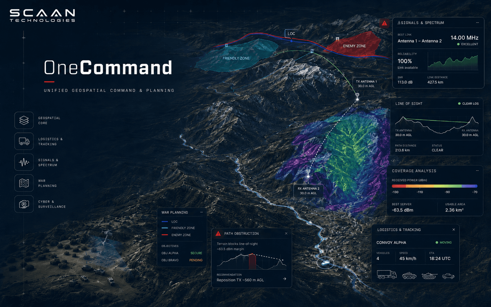
OneCommand is a GIS command and planning platform. Five capabilities sit on a single map surface — each deployable on its own, together forming the operational spine.
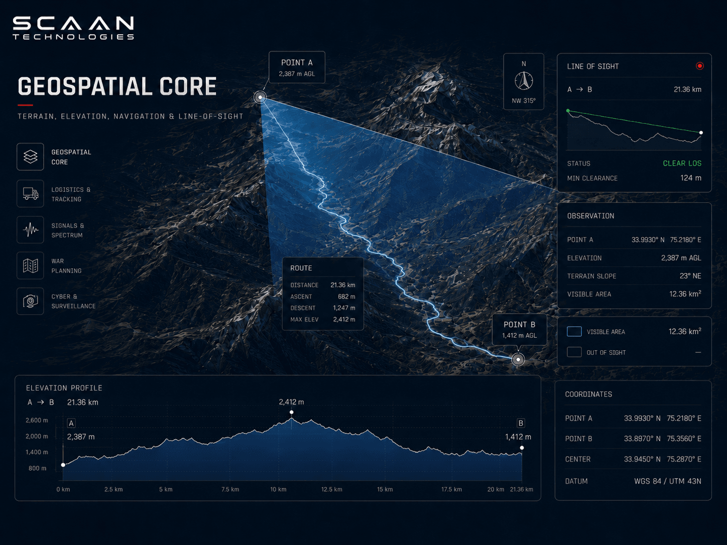
Geospatial Core
Terrain, elevation, and line-of-sight on a single map surface.
Multi-resolution terrain, navigation, and elevation profiling on a unified geospatial surface. Operators move from area study to mission plan without leaving the map.
Line-of-sight and viewshed analysis run against the same elevation model used for routing — answers are consistent across the tools an operator uses in a single session.
- 01Terrain visualisation and elevation profiling
- 02Navigation and route planning
- 03Point-to-point line-of-sight and viewshed analysis
- 04Multi-source tile and basemap ingestion
Logistics & Tracking
Live position for vehicles, convoys, fleets, and patrols.
Real-time positions and historical trails for every tracked asset — individual operators, vehicles, convoys, and fleet-scale formations. Patrol plans, geofences, and route deviations are observable in one place.
Movement is recorded against the authored plan, so deviations and dwell events surface immediately — not in the after-action review.
- 01Vehicle, convoy, and fleet tracking
- 02Unit and patrol movement with geofencing
- 03Historical trails and movement replay
- 04Route-deviation and dwell alerts

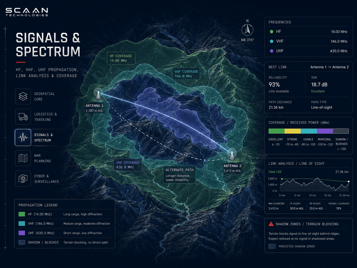
Signals & Spectrum
HF, VHF, and UHF propagation — modelled on the map.
Integrated signal-propagation modelling for the bands operators actually use. Voacap for HF skywave links; Splat for VHF and UHF terrain-aware coverage.
Frequency planning happens against the same terrain model used for routing and line-of-sight — coverage, shadow zones, and link feasibility are visible on one map.
- 01Voacap-based HF propagation modelling
- 02Splat-based VHF and UHF terrain-aware coverage
- 03Point-to-point link analysis with terrain
- 04Coverage maps and shadow-zone overlays
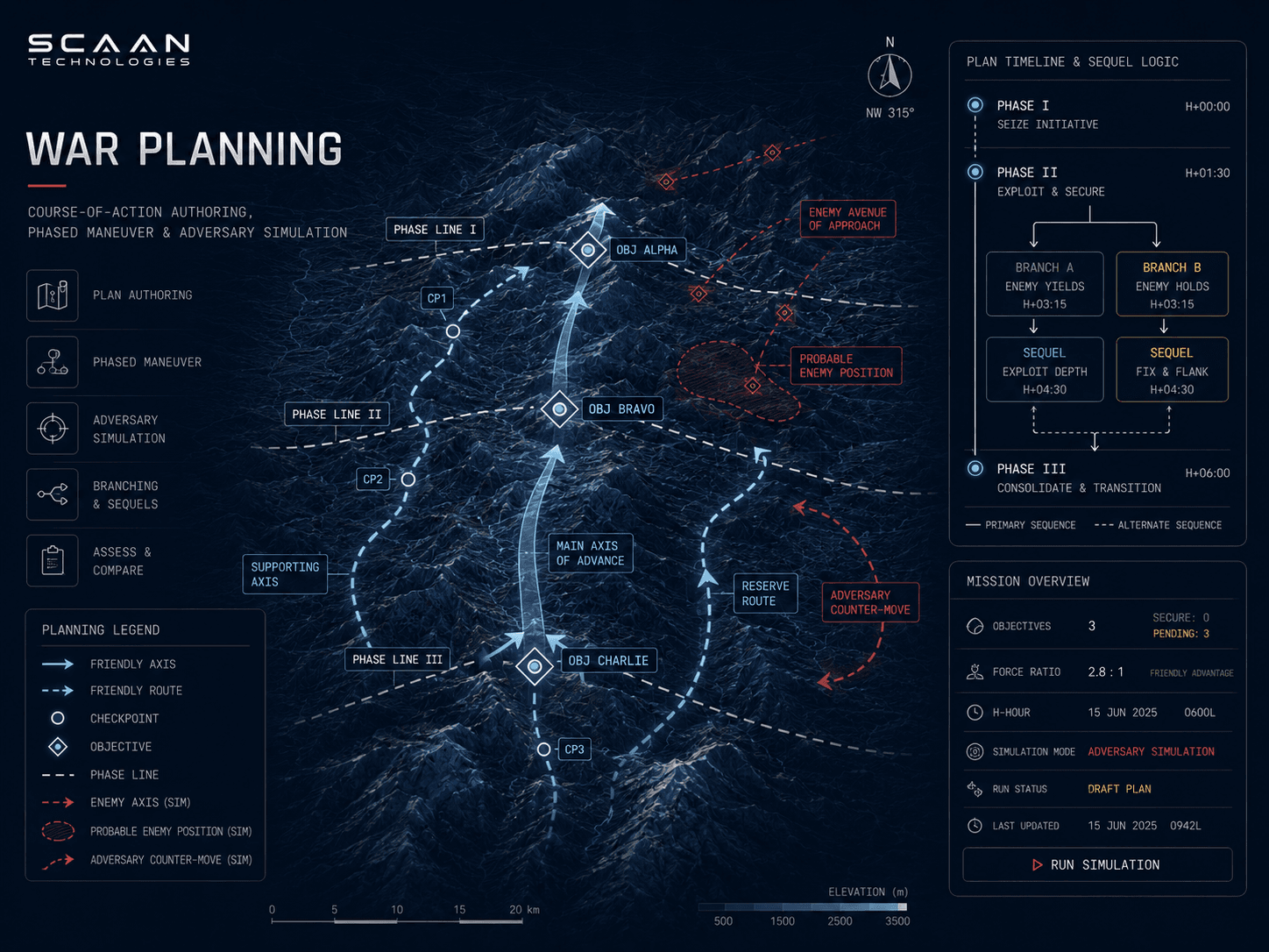
War Planning
From strategy and simulation to live operations.
Course-of-action authoring, adversary simulation, and operations execution — on the same surface used for the area study. Plans are rehearsed against parameterised threats before they are issued.
Hand-off from rehearsal to live operation does not require re-keying coordinates or exporting to a separate tool.
- 01Course-of-action authoring and review
- 02Parameterised adversary simulation and red-team
- 03Phase, branch, and sequel planning
- 04Hand-off from plan to live operation
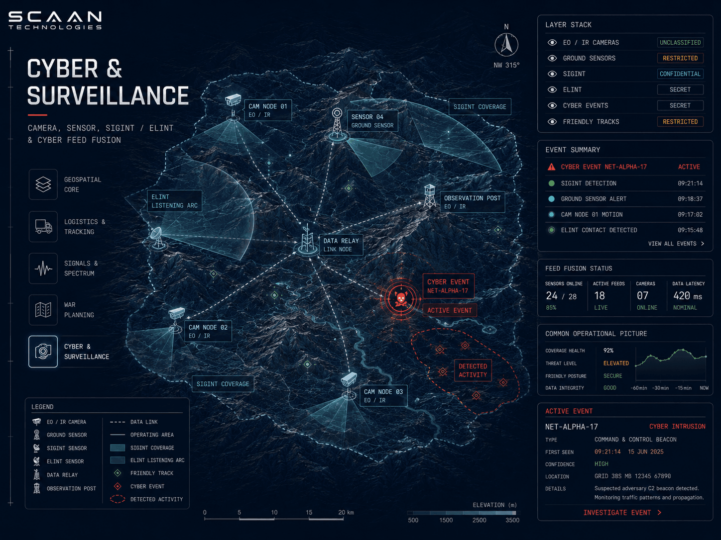
Cyber & Surveillance
Cyber posture and surveillance feeds on the operational map.
Cyber events and surveillance feeds — camera, sensor, SIGINT, ELINT — fuse into the common operational picture. Operators see the physical and the electromagnetic on a single surface.
Each layer carries its own classification and need-to-know handling, so the picture an operator sees is the one their clearance permits.
- 01Sensor and camera feed fusion
- 02SIGINT and ELINT overlays
- 03Cyber event geolocation and correlation
- 04Per-layer classification and need-to-know
Engineered for the environment you operate in.
Defence software lives where its operators do — not in a cloud region somebody else manages. OneCommand is engineered for the deployment posture the mission actually requires.
On-Prem
Customer-owned hardware. No cloud dependency.
Deploys on customer infrastructure — bare-metal, virtualised, or in private clouds you control. No call-home, no external license check.
Air-Gapped
Operates without internet.
Tiles, models, signatures, and updates are delivered offline via signed bundles. The platform never assumes a network it doesn't own.
Hardware-Bonded
Software bonded to your hardware.
Theft of disks or images does not leak access. Activation is tied to hardware identity and customer-controlled key material.
Multi-Site Sync
Site-to-site replication, conflict-aware.
Replication between sites over classified links, with deterministic conflict resolution and full audit. Designed for the bandwidth profiles you actually have.
How operators are using OneCommand.
Anonymised examples drawn from active engagements. Formation and unit identifiers are illustrative.
01
Corps Operations Cell
Area study, link analysis, and war-game in one session.
Operators move from terrain and line-of-sight study, through HF and VHF link modelling, into adversary simulation and final plan — without leaving the map surface.
02
Forward Logistics Node
Live convoy and patrol tracking against the route plan.
Convoys, patrols, and individual vehicles tracked against authored routes, with geofence and dwell alerts. Historical trails replay any movement window for review.
03
Joint Signals Centre
HF and VHF/UHF coverage planning for joint exercises.
Voacap and Splat propagation overlays drive frequency planning and coverage for joint formations. Shadow zones are visible on the same map operators use to brief.
Other platforms in the operational spine.
INDEA
Indigenous AI platform for on-prem inference, retrieval, and mission-tuned reasoning across classified data.
Learn MoreATMA
End-to-end training lifecycle management — curricula, assessments, readiness, and skills analytics.
Learn MoreHEART
Enterprise administration spine — HRMS, ERP, analytics, CRM and helpdesk, and learning management — on one platform.
Learn MoreBriefings on-prem, on-site, or under classification as your operation requires.
We'll come to you. Briefings cover engineering depth, deployment options, and the operational trade-offs you actually care about.